


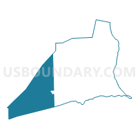
HARTLEY TWP Voting District, Union County, Pennsylvania
About
Outline

Summary
| Unique Area Identifier | 664040 |
| Name | HARTLEY TWP Voting District |
| County | Union County |
| State | Pennsylvania |
| Area (square miles) | 80.15 |
| Land Area (square miles) | 79.60 |
| Water Area (square miles) | 0.55 |
| % of Land Area | 99.32 |
| % of Water Area | 0.68 |
| Latitude of the Internal Point | 40.89491010 |
| Longtitude of the Internal Point | -77.26618040 |
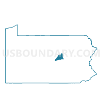
Maps

Graphs
Select a template below for downloading or customizing gragh for HARTLEY TWP Voting District, Union County, Pennsylvania


Neighbors
Neighoring Voting District (by Name) Neighboring Voting District on the Map
- ADAMS TWP Voting District, Snyder County, PA
- ARMAGH TWP VTD NEW, Mifflin County, PA
- ARMAGH TWP VTD OLD, Mifflin County, PA
- HAINES TWP Voting District, Centre County, PA
- HARTLETON Voting District, Union County, PA
- LEWIS TWP Voting District, Union County, PA
- MILES TWP VTD EAST, Centre County, PA
- SPRING TWP Voting District, Snyder County, PA
- WEST BEAVER TWP Voting District, Snyder County, PA
Top 10 Neighboring County Subdivision (by Population) Neighboring County Subdivision on the Map
- Armagh township, Mifflin County, PA (3,863)
- Miles township, Centre County, PA (1,983)
- Hartley township, Union County, PA (1,820)
- Spring township, Snyder County, PA (1,616)
- Haines township, Centre County, PA (1,564)
- Lewis township, Union County, PA (1,480)
- West Beaver township, Snyder County, PA (1,110)
- Adams township, Snyder County, PA (907)
- Hartleton borough, Union County, PA (283)
Top 10 Neighboring Place (by Population) Neighboring Place on the Map
Top 10 Neighboring Unified School District (by Population) Neighboring Unified School District on the Map
- Mifflin County School District, PA (43,607)
- Midd-West School District, PA (17,458)
- Mifflinburg Area School District, PA (16,360)
- Penns Valley Area School District, PA (12,819)
Top 10 Neighboring State Legislative District Lower Chamber (by Population) Neighboring State Legislative District Lower Chamber on the Map
- State House District 171, PA (67,294)
- State House District 85, PA (66,182)
- State House District 82, PA (64,036)
- State House District 76, PA (63,384)
Top 10 Neighboring State Legislative District Upper Chamber (by Population) Neighboring State Legislative District Upper Chamber on the Map
Top 10 Neighboring 111th Congressional District (by Population) Neighboring 111th Congressional District on the Map
Top 10 Neighboring Census Tract (by Population) Neighboring Census Tract on the Map
- Census Tract 902, Union County, PA (6,452)
- Census Tract 704, Snyder County, PA (5,651)
- Census Tract 108, Centre County, PA (5,632)
- Census Tract 9601, Mifflin County, PA (3,863)
- Census Tract 705, Snyder County, PA (3,667)
Top 10 Neighboring 5-Digit ZIP Code Tabulation Area (by Population) Neighboring 5-Digit ZIP Code Tabulation Area on the Map
- 17844, PA (10,042)
- 17842, PA (8,910)
- 17841, PA (4,779)
- 17063, PA (3,311)
- 17845, PA (2,245)
- 17813, PA (1,979)
- 16872, PA (1,551)
- 16820, PA (1,217)
- 16882, PA (300)
- 17829, PA (244)